Circling the Wind River Range
Friday, July 22, 2005: I went in search of more birds by visiting the Bridger-Teton National Forest at the far end of the Buffalo Valley Road. I found three new trip birds, Sage Thrasher, Orange-crowned Warbler, and Red Crossbill. I also found where all the Cassin's Finches have been hiding. Other birds were present, particularly a noisy group of Gray Jays. From there, I headed east on US-26/287.
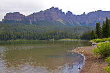
After topping Togwotee Pass, my next stop was at Brooks Lake, which is several miles from the highway on a forest road. It has a nice view of Pinnacle Butte. Returning to the highway, I continued east with the plan of looping the Wind River Range. The highway runs along the Wind River for some time. As I drove along, I was struck by the difference in landforms on the two sides of the highway. Red rock country was on the left, complete with canyons. On the right, the terrain was much softer, making me wonder if the hills were unconsolidated debris from the mountains, possibly glacial.
 |
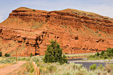 |
| Pinnacle Butte | Red Rock on US-287 |
|---|
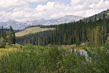
To complete the loop, I followed US-287 through Lander, then WY-28 over South Pass (Oregon Trail, there are a number of historical markers) to Farson (where the Oregon Trail goes southwest to Ft. Bridger), finally returning on US-191. The return path through Hoback Canyon was scenic and I stopped a couple of times for photos. I made another stop at the Elk Refuge ponds before returning to Signal Mountain Lodge.
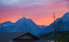
I ate an early dinner. This was good as a major storm blew in right after I got back to my cabin. It was a violent storm with strong winds and lots of lightning and thunder. I was glad I was in the cabin! The storm ended shortly before sunset. At one point I happened to look out and noticed the colors in the sky. I managed to take a few photos from the porch before the color changed.
 |
 |
 |
| Hoback Canyon | Teton Sunset | |
|---|---|---|
Birds: 154. Mammals: 27.
Jackson, WY
Grand Teton Mountain
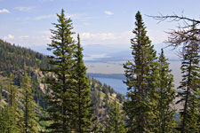
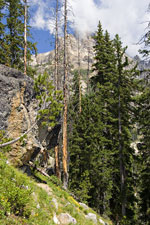
Saturday, July 23, 2005: It's the last day of vacation. Originally, I'd planned to leave right away. After thinking about it, I think I have time for a hike to either Garnet Canyon or Amphitheater Lake. In any event, I'll start up the trail and see how time goes. So I checked out and headed to the Lupine Meadows Trailhead. It's more than 3 miles to the junction for the two trails and I'd decided to go for Amphitheater by the time I got there. I learned a little about mountain hiking on the way up. While resting, I was passed a couple of times by groups of mountaineers. I noticed they were moving more slowly than I would have thought, so I decided to follow one group and emulate them. It turns out I've been going too fast and its been slowing me down! It slows me down because I have to rest. Following these mountaineers, I eventually had to rest too, but it took quite a bit longer to happen.
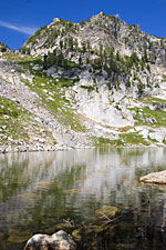
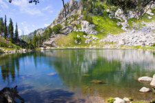
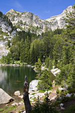
I got to Amphitheater around 10:30, which was earlier than I had expected. I relaxed for a while and took some pictures. At one point a bird appeared near me. It was a Hermit Thrush. Then it and a White-crowned Sparrow flew to the other side of the lake. I decided to wait a bit and see what else appeared. Then this dark bird appears in the same area. Yep! A Black Rosy-finch! The last two times I've seen them, I hiked a long way and wasn't expecting them when they appeared. My stay at Surprise Lake was shorter, then I headed down. Two Brown Creepers singing partway down provided my last new birds of the trip.
 |
 |
| Jenny and Jackson Lakes | Teewinot View |
|---|
 |
 |
 |
| Amphitheater Lake | Surprise Lake | |
|---|---|---|
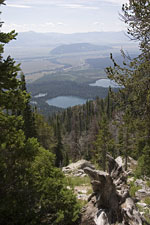
This hike also shows how much better hiking shape I'm in now than at the beginning of the trip. I got back to the car at 1:15. According to my GPS, I'd gained 2950 feet and hiked 10.5 miles (the guidebook says less, I think the GPS was right). This hike was about the same length as the Iceberg Lake hike in Glacier, but it gained an extra 1700 feet and was a higher altitude (as much as 3500 feet). Nonetheless, I did it more than an hour more quickly. On top of that, I was really tired out after the Iceberg hike. After this one, I was ready to do a few more miles.
 |
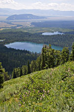 |
| Taggart and Bradley Lakes | |
|---|---|
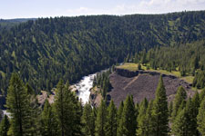
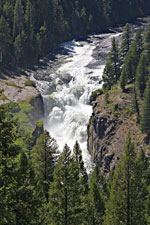
Although it is longer, I drove down to Jackson, then over Teton Pass into Idaho. Some of the traffic is really slow going up Teton Pass. Vehicles with trailers were going around 20. Even once I got clear, it was hard to go much more than 40. This is a steep road! I was wishing I had my FX. From Idaho, I viewed the backside of the Tetons, then visited Lower and Upper Mesa Falls in the Island Park area. The drive through Montana was also scenic, but by now I was paying more attention to getting to Helena at a reasonable hour so I would have time to re-pack at get at least 5 hours sleep before my early flight tomorrow. I'll have to come back and see more of Idaho and Montana.
 |
 |
 |
| West Side of the Tetons | Lower Mesa Falls | |
|---|---|---|
 |
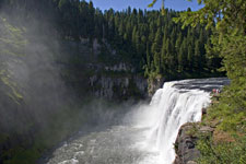 |
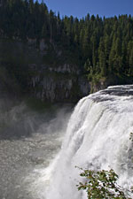 |
| Lower Mesa Falls | Upper Mesa Falls | |
Birds: 156. Mammals: 27.
Helena, MT
Home!
Sunday, July 24, 2005: It was an uneventful set of flights home (the best kind!), Helena to Salt Lake to Atlanta to Miami. Luggage started appearing at the carousel unusually quickly. Mine was in the second batch and I was home in less than an hour after I walked off the jetway.
Miami FL