Washburn Déjà Vu
Monday, July 11, 2005: When I was in Yellowstone 3 years ago, I walked up Mt. Washburn from Dunraven Pass. I decided to visit Mt. Washburn again. As anticipated, the trail (old road) from Dunraven was closed due to road construction. Another way to the top is to take the road from Chittenden, which is used to supply the fire tower. That's what I did. There is a third way up, hiking from Canyon Village, but it's substantially longer. Maybe I'll take it next time I'm in Yellowstone!
It took a while to get to Mt. Washburn from Mammoth, so I didn't start up the trail until after 8. That was fine as the clouds had been hanging around the mountains and I had some fog to drive through. By the time I got to the trailhead, the fog had lifted. I was the first on the mountain and the first at the top (the fire lookout, who lives there, doesn't count). I spent 2 hours going up, an hour at the top, and over an hour coming down.
Although the trail from Chittenden is less interesting than the trail from Dunraven, it's probably good for people doing their first mountain (the trail from Dunraven is also good, if you don't mind a little exposure near the summit). The trail is not too long (3 miles to the summit) and it doesn't climb too far (1500 feet). For this relatively small effort you get outstanding views from the top. It's the tallest thing in the neighborhood. As John Cheney said (echoing Cooper's Natty Bumppo) after making the first ascent of Mount Marcy, “it makes a man feel what it is to have all creation under his feet”.
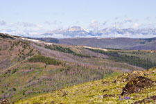
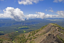
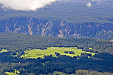
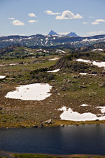
At the top, you can see the Yellowstone Gorge, Lake Yellowstone, and many other areas of the park. On a clear day, you can see the Tetons. You get the true alpine experience with meadows and wildflowers. There are even some snowbanks around. You do have to be acclimated to the altitude as the summit is over 10,000 feet. The trail is really a dirt road that is still in light use to supply the fire lookout. As such, the footing is excellent (no nasty rocks or roots grabbing at your feet) and the grade is pretty steady all of the 3 miles to the top (it flattens slightly near the top). There's even a bench to rest on. There's a restroom at the top. If you need to get out of the wind and weather, there's an enclosed viewing area with telescope and interpretative signs and panoramas.
 |
 |
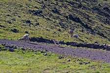 |
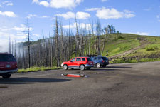
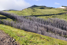
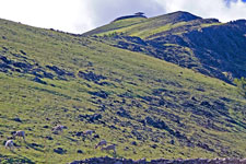
| Chittenden Trailhead | The Road up Washburn | Washburn Bighorns |
|---|---|---|
 |
 |
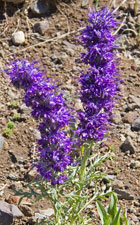 |
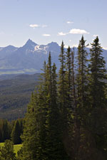
| Dunraven Peak | Fire Tower & Bighorns | Sikly Phacelia |
On the way up, I saw lots of wildflowers and Mountain Bluebirds. There were 10 Bighorn Sheep (no adult males) near the bench. They were blocking the road when I got there so I sat on the bench and watched them a bit. When I got up, they moved out of the way. One was a bit slow to go over the side and the sheep behind butted her. A little farther up I found a Blue Grouse who didn't stay in view quite long enough for me to get my camera out of the pack and change lenses. Horned Larks were present near the top and I saw at least 6 Yellow-bellied Marmots on the way. The supply vehicle came up after I'd been at the top for about half an hour.
 |
 |
 |
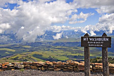
| The View South | Washburn Summit | Yellowstone Gorge |
|---|
Driving back through the Antelope Valley I noticed some people stopped at an overlook. They had spotted a grizzly in the distance. When I got to Roosevelt, I took the road toward the NE entrance, following it all of the way out of the park.
Beartooth!
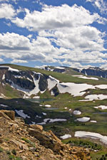
There were construction delays shortly after leaving the park, but I eventually made my way out the Beartooth Highway. This is the road Charles Kuralt called the most beautiful highway in America. I don't know if he was right, but the road is certainly one of the leading contenders. The tree removal from the widening project west of the Top of the World Store has lessened the charm of that part of the road, but the alpine areas east of the store are still spectacular.
Several mudslides in May severed the road in Montana, so you couldn't take it to Red Lodge this summer. However, the Beartooth Pass was still accessible and that's where I headed. At one stop I saw a Prairie Falcon zoom by. At another, I noticed an animal I first took to be a marmot. However, it didn't look right. Then I noticed the vertical white stripe on its face. Marmots have white, but not a vertical stripe. It was a Badger! I was really surprised! Later, I read that badgers visit alpine areas in summer to hunt marmots and other prey.
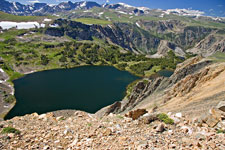 |
 |
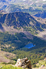 |
| Twin Lakes | Alpine Lakes | Alpine Lake |
|---|---|---|
 |
 |
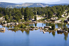 |
| Pilot and Index Peaks | Frozen Lake | |
Yellowstone Wildlife
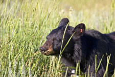
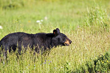
When I came back, there was more wildlife activity at Lamar and Roosevelt. I saw a distant grizzly in Lamar, then a Coyote that crossed the road. Finally, there was a Black Bear feeding near the road not far from Roosevelt, which created a bear jam. Most people were pretty good about finding a place to pull off (this is not always the case) and I joined them. The bear moved closer to the road while we were all watching and photographing it. At one point, I decided to retreat as the bear was getting too close. Others took this as an opportunity to close in on the bear with their point-and-shoot cameras. Fortunately, Black Bears are usually pretty tolerant of humans and their antics. This one basically ignored the crowd and no harm came to bear or human.
 |
 |
| Black Bear | |
|---|---|
Birds: 133. Mammals: 24.
Mammoth Hot Springs, WY